

Flooding is one of the most common and costly natural disasters, affecting homes and communities across the U.S. Whether you live near a river, on the coast, or even in a seemingly 'low-risk' area, understanding flood zones is critical for safeguarding your property and loved ones.
When you think of ‘Emergency Preparedness,’ understanding flood zones is probably one of the first things that come to mind. Well, it’s a geographic area that is flood-prone. Simple as that!
This guide discusses what are flood risk zones, how to identify them, and what impacts they have on homeowners and renters.
Decoding FEMA Flood Risk Areas
When you begin to learn about flood risk zones, it can be a lot to take in. However, slowly and gradually, you'll get the hang of it. You should know that if you’re living in a flood-prone area, learning about the flood risk zones is important for your safety.
FEMA, alongside other federal agencies, has spent decades developing flood risk assessment programs using advanced mapping technology. Their maps serve as fundamental infrastructure for assessing flood insurance costs and enforcing building regulations that guide local development plans.
The flood risk maps available on FEMA websites feature several different letters including A, V, X, and additional designations. The various zone designations convey important details regarding the frequency scale and flood severity potential in affected areas.
Categorizing Flood Zones Into Letters
Flood zones can be categorized into various letters for better understanding. Each of the letters signifies essential information about an area that is prone to flooding. Let’s break it down further:
- Zone A: This zone can be labeled as a high-risk flood zone area because it poses a 1% annual chance of being hit by a flood. Moreover, it is also referred to as the 100-year flood. If your home happens to fall into zone A, make sure that you get flood insurance.
- Zones AE, A1-A30: These zones are also subject to the 1% annual chance of flood, but unlike Zone A, they include detailed flood elevation data. Flood insurance shouldn’t be neglected.
- Zone AH: This designation applies to areas with shallow flooding (typically from ponding) that can reach depths of 1 to 3 feet. BFEs are available. Again, insurance is mandatory.
- Zone AO: Similar to Zone AH, this category covers shallow flooding of 1 to 3 feet, but it usually results from sheet flow over sloped terrain rather than ponding. Flood depths are noted, and insurance is required.
- Zone AR: This zone includes areas where a previously certified flood protection system (such as levees) is undergoing restoration. Despite efforts to improve protection, flood insurance remains a requirement.
- Zone A99: These areas will eventually be protected by a federal flood control system that is still under construction. While the project isn’t finished, it has made enough progress to qualify for insurance purposes. No BFEs are listed, but insurance is still required.
|
Flood Zone |
Risk Level |
Key Characteristics |
|
Zone A |
High Risk |
1% annual chance of flooding (“100-year flood”). No Base Flood Elevation (BFE) data. |
|
Zones AE, A1-A30 |
High Risk |
1% annual flood chance with detailed BFE data. Often located in floodplain areas. |
|
Zone AH |
High Risk |
Shallow flooding (1 to 3 feet), typically ponding. Includes BFE data. |
|
Zone AO |
High Risk |
Shallow flooding (1 to 3 feet), usually from sheet flow over sloped terrain. |
|
Zone AR |
High Risk (Restoration) |
Area with flood protection (e.g., levees) under restoration. Still considered high risk. |
|
Zone A99 |
High Risk (Under Construction) |
Flood control systems are being built but are incomplete. No BFE data yet. |
Coastal Flood Zones:
- Zone V: Coastal areas at risk of a 1% annual chance of flood, with added danger from storm waves. Because detailed studies haven’t been conducted, there are no BFEs listed, but insurance is required.
- Zones VE, V1-V30: These coastal regions also face a 1% annual chance of flood but have detailed analyses showing BFEs and additional risks from wave action. Flood insurance is mandatory.
Other Flood Risk Areas With Moderate to Minimal Flood Risks:
- Zone D: This zone indicates areas where flood risks are uncertain because no official analysis has been conducted. Insurance is not required but may be considered.
- Zones X (shaded) and B: These areas have a moderate flood risk, typically located between the 100-year and 500-year floodplain boundaries. Insurance is recommended but not mandatory. (Zone B is now being replaced by shaded Zone X on updated flood maps.)
- Zones X (unshaded) and C: These areas have minimal flood risk, lying outside the 500-year floodplain. Insurance is generally not required. (Zone C is being replaced by unshaded Zone X on new maps.)
|
Flood Zone |
Risk Level |
Key Characteristics |
|
Zone V |
High Risk (Coastal) |
1% annual flood chance. At additional risk from storm waves. |
|
Zones VE, V1-V30 |
High Risk (Coastal) |
1% annual chance of flooding. Includes storm wave analysis and detailed BFEs. |
|
Zone D |
Undetermined Risk |
Areas where flood risks are uncertain; no analysis conducted. |
|
Zone X (Shaded), B |
Moderate Risk |
Areas near the 100-and 500-year floodplains. 0.2% annual flood chance (“500-year flood”). |
|
Zone X (Unshaded), C |
Minimal Risk |
Areas outside the 500-year floodplain with very low flood risk. |
The methods FEMA employs follow both precise and well-ordered procedures. Professional teams at FEMA estimate flood areas and timings by analyzing historical flood information and hydrological models by running computer simulations.
The flood maps provide essential information, but they contain certain weaknesses which need to be taken into consideration. The changing environment combined with outdated data leads to areas of unknown flood risks in maps. In this context, you need to understand that flood zones represent just one aspect of wider flood-related information.
How Flood Risk is Assessed
Having insights into how flood risk zones work will help you make better choices. The procedure used by FEMA consists of evaluating river flow data together with rainfall patterns and landscape features. The organization strives to establish projections about locations that could become flooded during flood events. For many residents, a recurring question is, What is a flood zone? And the answer lies in the combination of scientific analysis and historical trends.
The precise flood depths calculated by engineers in areas under hydraulic analysis receive AE or V1-V30 designations. These areas contain Base Flood Elevations (BFEs) on the maps because these elevations display the predicted water height during flood events. Areas designated with basic labels such as “A” or “V” imply imprecise mapping techniques.
The classification systems establish both rates for flood insurance and the necessary floodplain management guidelines applicable to each area.
If you’re ever reviewing property documents or planning a new build, you might come across technical jargon. Instead of getting overwhelmed, focus on the bottom line: knowing what a flood zone is in your area can guide your insurance decisions and future planning. Remember, while these classifications are useful, they may not capture every nuance of flood risk. Environmental shifts, like increased rainfall or rising sea levels, can alter the risk profile over time.
Understanding FEMA flood zones not only informs safety and preparedness, but also significantly impacts property values and long-term financial planning.
Impacts of flood zones
The flood risk label assigned to real estate properties significantly influences them. You need to determine the flood zone status before purchasing a house since it remains among the initial questions you should ask when buying property. Homes situated in flood-prone zones have to adhere to mandatory flood insurance policies, which become part of your home financing and long-term investment costs.
Properties located in high-risk areas carry additional building and insurance requirements that make up the two classification types A or V. Residential properties in these zones encounter difficulties regarding property market valuation. Buyers tend to be reluctant, and lenders enforce complex conditions that result in restricted financing possibilities. Being informed about your flood zone position prepares you for financial consequences while allowing you to study protective methods against risks.
Surprisingly, moving into a less flood-prone region does not create 100% protection from flood harm as well. Since the National Flood Insurance Program began, more than 20% of its total insurance claims originated from areas that the program designated as low-risk. Therefore, as a precautionary measure, every person should learn about what a flood zone is, and its impact on their everyday routines.
Flood risk exists beyond its mapping label because it directly shapes emergency services, community planning, and local infrastructure development. Knowledge of flood zones allows communities to make investments, strengthen flood defense systems, enhance drainage facilities, and prepare for extreme weather events.
When you understand what a flood zone is-you’ll be one step closer to safety.
Practical Preparedness: Steps You Can Take
Moving forward, let’s explore the suitable actions people can take when living in areas that experience flood risks. Your first priority should be learning about the flood zones present in your local area. By using FEMA's online search tools and entering your address, you can identify the flood zone where your property belongs.
After obtaining the required information, you should think about implementing preventive plans. Here are a few suggestions:
1. Stay Informed:
Sign up for local weather warning systems along with community advisory notifications. Your preparedness allows you to spot hazardous weather conditions in a timely fashion.
2. Prepare an Emergency Kit:
Prepare a survival kit containing water, unspoilable food items, medical supplies, and essential paperwork. Being prepared is a critical factor that determines your survival during natural disasters.
3. Invest in Flood Mitigation:
Basic home improvement projects that incorporate sump pumps and basement reinforcements will substantially decrease the effects of flooding on your house. This is especially important if you’re living in an area where you’ve had to ask yourself repeatedly, what is a flood zone?
4. Consider Portable Power Solutions:
Power outages become a severe problem in locations that are prone to flooding. It becomes essential to power essential devices such as sump pumps, communication tools, and emergency lighting during grid outages. That’s where portable power solutions serve as a beacon of hope.
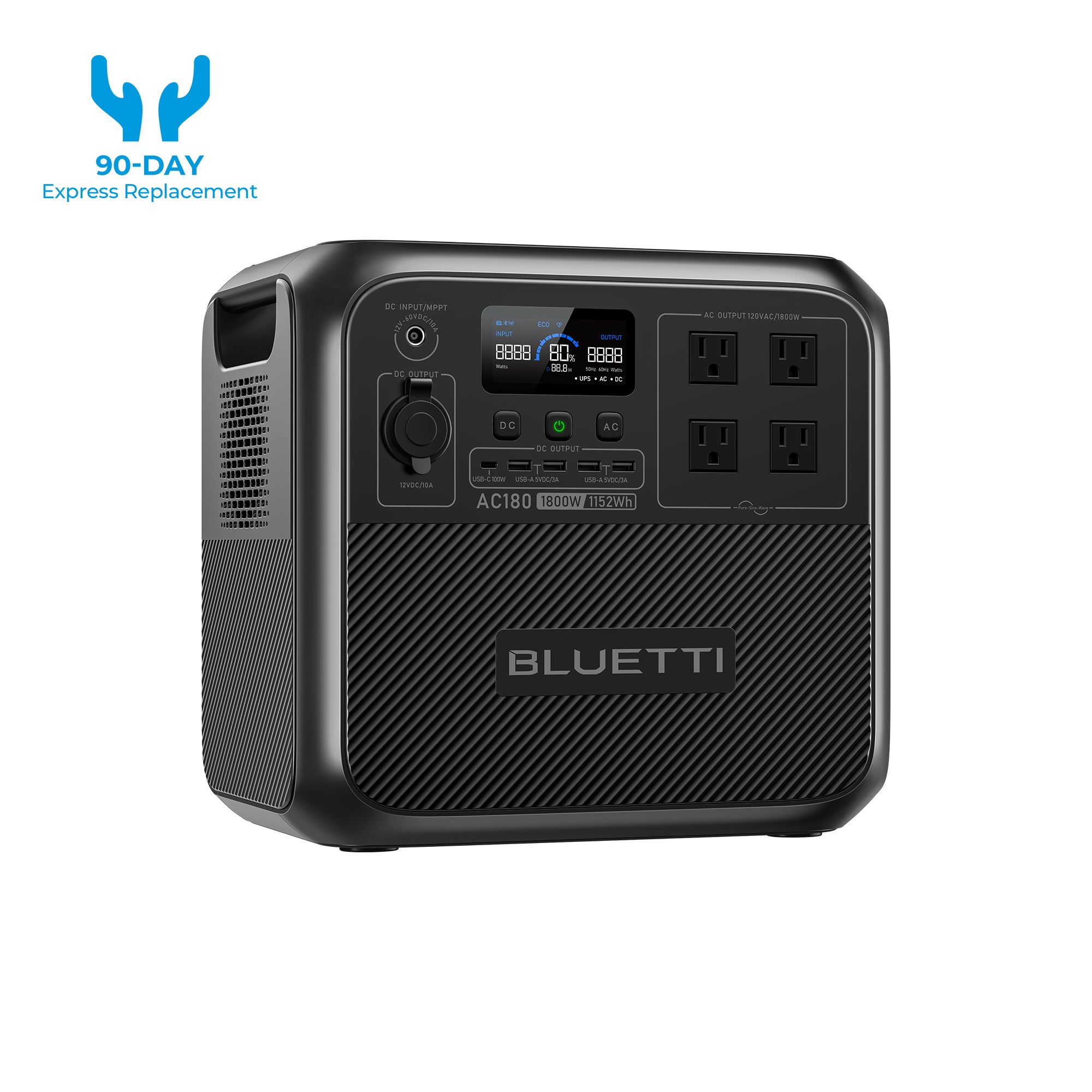
Bluetti AC180: Heavy-Duty Reliability

The Bluetti AC180 power station exists specifically to handle extensive power needs during flood incidents. What sets it apart are these features:
- High Battery: A high-capacity battery system powers continuous operations such as sump pumps, thus preventing basement flooding during power outages.
- Multiple Outlets: The power station features numerous AC outlets with USB ports and car connectors, which allow you to operate different devices simultaneously.
- Heavy-Duty Performance: The device operates as an ideal solution to energize heavy equipment and essential equipment while extended power outages exist.
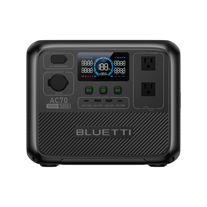
Bluetti AC70: Compact Versatility
As a portable power solution, the Bluetti AC70 would interest those with mobility requirements. A smaller footprint does not limit the performance capabilities of this device.
- The device is both portable and lightweight, which enables its use across different emergency situations.
- The power supply system charges phones, radios, laptops, and smaller appliances so you can communicate and stay updated.
- When major necessities fail, the Bluetti AC70 maintains the operational capability for all emergency lighting solutions and basic appliances and communication tools.
The compact model offers suitable power backup for tight spaces where unsuspected blackouts require reliable power support.
Both the Bluetti AC180 and AC70 come packed with features designed to enhance your flood preparedness:
- The device uses advanced battery management for maximum output stability allowing it to function reliably during emergencies.
- Both units provide effortless setup and straightforward operation, which maintains functionality despite high-pressure conditions.
- The safety features integrated into the devices protect users and their equipment from power surge hazards alongside electrical problems.
Every passing moment becomes critical during flood situations. The combination of the Bluetti AC180 and the Bluetti AC70 portable power solutions allows you to protect your residence and family members in emergency situations. The products provide users with powerful solutions that ensure all devices remain functional during emergencies, whether they require general-purpose or sump pump capabilities.
5. Review Your Insurance Policy:
Your insurance plan must account for elevated flood risks whenever your property stands in a vulnerable region. The knowledge of what a flood zone is and the various risks allows you to determine if you require a policy upgrade or additional risk mitigation measures.
Through solid action and knowledge about flood zones, you protect your home while safeguarding your loved ones. At present, a few preventive steps will serve to minimize future frustrations and financial obligations.
Embracing Technology and Innovative Tools
Field research in flood risk assessment continues to transform because technology stands as its core driver. The current FEMA mapping system offers essential knowledge, but next-generation platforms deliver more targeted and site-specific information about floods.
Additionally, the advanced systems utilize real-time data along with past flood trends and predicted threat models to generate complete flood risk profiles. Hence, we can say that technology provides better clarity about what constitutes a flood zone by delivering more useful information.
One such tool is the Flood Factor. It enables users to access more advanced flood risk information beyond standard FEMA mappings.
Flood Factor® delivers property-based flood risk assessments, including predictions about sea level rise and adjustments in precipitation behavior. Homeowners who use it, receive detailed knowledge about their flood zone status and future risk indications. Using such technology tools will enable you to develop strategies for both short-term security arrangements and strategic property evolution.
The Long-Term Picture: Adapting to a Changing Environment
Flood risk isn’t static. The modifications from urban expansion and environmental shifts, together with shifting weather patterns, will cause permanent changes to flood-risk areas over time. Safe zones present today can later evolve into hazardous locations the following day. Therefore, performing an evaluation of flood zones is necessary when considering how climate change affects them.
You need to monitor the new flood maps and residential plans that exist in your area. FEMA must conduct updates of its Flood Insurance Rate Maps every five years, but many maps remain unavailable because of limited funding.
Using flood maps as your sole source of information might result in inaccurate decisions. Therefore, you should enhance your research by integrating resources and tools that predict modern trends, including sea level rise coupled with increased precipitation levels.
The important feature of community-level planning comes next. Public administrations throughout the country continue their efforts to strengthen flood defenses and modernize their infrastructure systems.
As a civic participant, you should attend local meetings and initiatives that focus on enhancing floodplain administration. Knowledge about flood zones at individual and communal levels lays the groundwork for community-wide preparedness against natural disasters.
Flood risk demonstrates an active pattern that you need to analyze during your evaluation process. Information about flood zones can be altered by updated environmental data and changes in environmental conditions.
I believe communication between community members and local government organizations through constant learning remains essential. Putting these changes at the forefront of your awareness allows you to make necessary adaptations that protect your home and community's risky properties.
Final Thoughts
Flood preparedness starts with education. I hope this article has educated you on what a flood zone is, the associated risks, and what steps to take. Whether you're investing in flood insurance, reinforcing your home, or equipping yourself with a power solution like the Bluetti AC180, every small step brings you closer to safety. Start today!
Shop products from this article
You May Also Like

California Wildfire Preparedness Guide For Homeowners: Surviving PSPS, Smoke, And Evacuation

Tornado Emergency Kit Checklist For Families: Power, Medical, And Survival Essentials
